Live Weather from WRUF-TV
Current Conditions
Weather Forecast from FPREN
Latest Weather News
-
 Dangerous rip currents will be at a high risk along the Florida panhandle through Sunday with an increased risk along the Gulf coast beaches as well.
 -
 Rounds of storms to end the week, especially the most severe for the western Panhandle, but some storms could move over the rest of the state throughout the weekend.


-
 Multiple rounds of potentially severe thunderstorms are possible over Florida's Panhandle and North Florida Thursday afternoon through Friday night. Interests in these areas should continue to seek forecast updates, and are urged to heed any warnings issued for their location.
 -
 Much of Florida will experience July-like temperatures, with high heat indices to close the week. Many hot records will be broken or tied.
 -

-
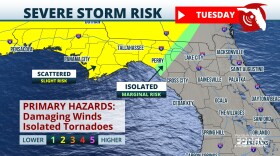 Strong spring storm system to elevate risk for strong storms across Florida Tuesday night and Wednesday
 -
 Severe storms with flooding risk across north Florida through Wednesday
 -
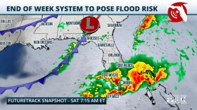 A developing storm should produce multiple rounds of heavy rain over parts of Florida on Friday and Saturday. Localized flooding is expected over parts of South Florida. Severe thunderstorms are possible along the immediate Gulf Coast of Florida.
 -
 The countdown to hurricane season has begun, and Florida emergency management offices are sharing their safety tips to empower residents to act ahead of potential storms.
 -
 As spring break approaches and travelers make their way to the Sunshine State’s beach towns, local authorities and lifeguards want you and your family to prioritize safety when soaking up the sun.
 -
 A storm system developing over the Plains Thursday will create a risk for strong thunderstorms over the Panhandle and the I-10 corridor in North Florida late Friday and through the day Saturday.
 -
 El Nino contributed to Florida's cool winter, La Nina to arrive by summer and could influence hurricane season


