Live Weather from WRUF-TV
Current Conditions
Weather Forecast from FPREN
Latest Weather News
-
 Strong spring storm system to elevate risk for strong storms across Florida Tuesday night and Wednesday
 -
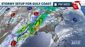
 Severe storms with flooding risk across north Florida through Wednesday


-
 A storm system developing over the Plains Thursday will create a risk for strong thunderstorms over the Panhandle and the I-10 corridor in North Florida late Friday and through the day Saturday.
 -
 El Nino contributed to Florida's cool winter, La Nina to arrive by summer and could influence hurricane season
 -
 William “Chip” Maxham joined the Florida Public Radio Emergency Network (FPREN), the WUFT Public Media Weather team and the South Carolina Emergency Information Network (SCEIN) as a meteorologist in January 2024.
 -

-
 The National Hurricane Center (NHC) will be implementing a new experimental cone graphic to display critical watches and warnings for inland counties during hurricane season.
 -
 The Florida Division of Emergency Management (FDEM) and the National Weather Service are recognizing this week as Severe Weather Awareness Week. Drawing attention to several weather hazards, the campaign aims to share information on how to prepare and respond to natural disasters.
 -
 A storm system should arrive to the state on Sunday. Multiple rounds of heavy rain could lead to local flash flooding. Isolated strong wind gusts and brief tornadoes are possible too.
 -
 Above normal rainfall this winter could lead to a less active wildfire season across parts of Florida
 -
 Rounds of thunderstorms could lead to localized flooding over Florida's Panhandle. Meanwhile, over the peninsula, the warm trend will continue until the end of the weekend.
 -
 Temperatures plunged into the 20s over the weekend, and the wind chill made it feel more like the teens. That was the coldest it’s been all winter and prompted Alachua and surrounding counties to be placed under a freeze watch.


